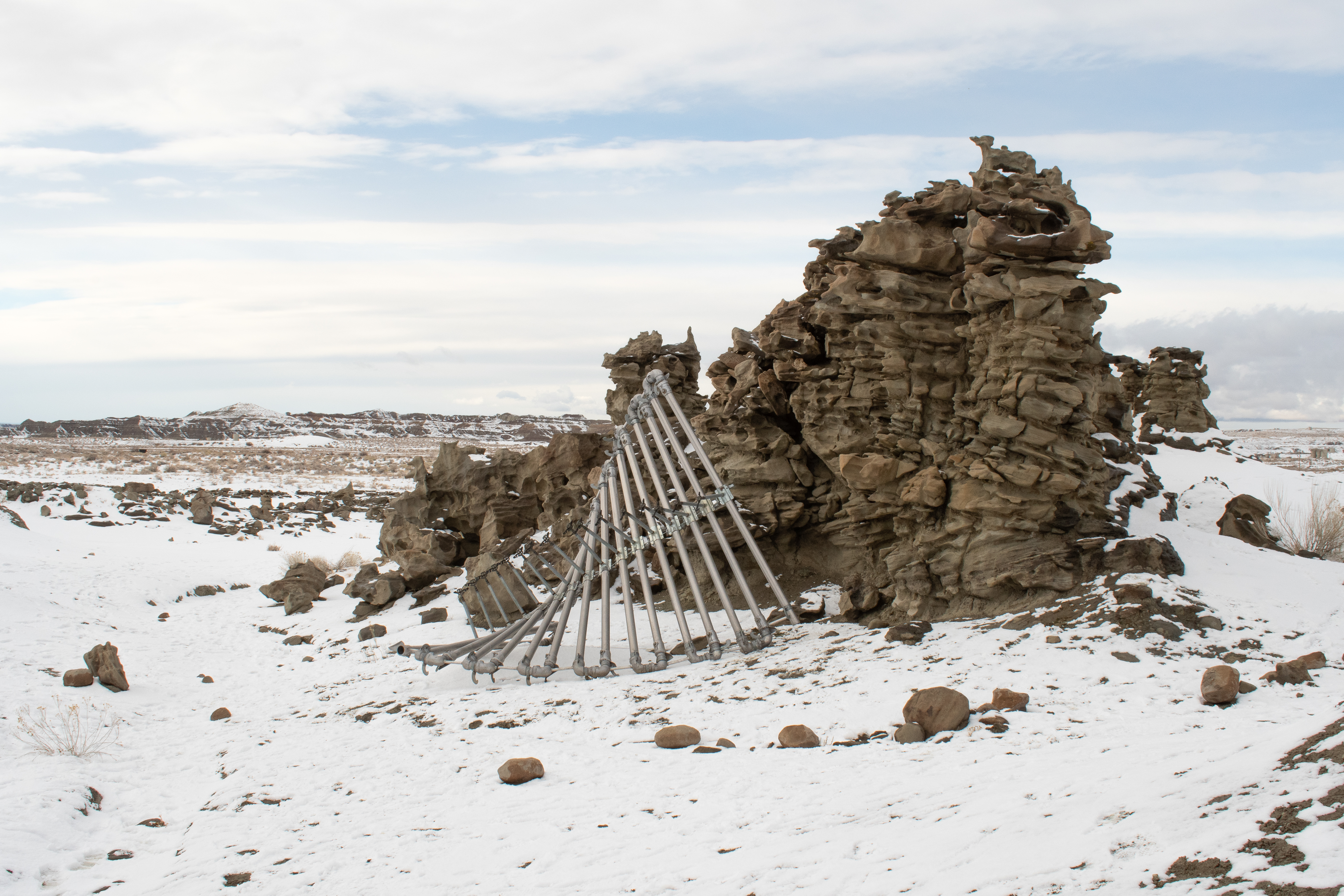
Fantasy Canyon
Adam Bateman
Fantasy Canyon
Vernal
Utah, United States
May 10, 2022
Eocene Epoch quartzose sandstone, magnetite, gilsonite, functional industrial crop sprinkler hardware arranged in a helix, snow.
Dimensions variable.
“The sandstone layer in which the pinnacles, pillars, arches, and knobs of Fantasy Canyon, Utah, are formed consists of ancient river channel sediments. The underlying and overlying rock layers sandwiching the sandstone layer, and creating scenic badland topography around the canyon, are finer grained floodplain deposits.
During the Eocene Epoch, 55 to 34 million years ago, the Fantasy Canyon area was at the fringe of a vast subtropical lake–Lake Uinta–that at peak level stretched from the Wasatch Plateau to western Colorado. The lake was in a drying phase and retreating westward by the end of the Eocene.
Rivers en route to the dwindling lake deposited sand, silt, and clay shed from nearby mountains. Once buried, these sediments eventually solidified into layers of sandstone, mudstone, and claystone. Collectively these rocks are a part of the Uinta Formation that spans extensive areas of the Uinta Basin and nearby Colorado.
Differences in the rate of weathering and erosion between dissimilar rock types ultimately shaped Fantasy Canyon. The mudstone and claystone have been stripped away by water and wind, leaving the slightly more durable sandstone to be carved into bizarre, melted wax-like forms.”1
Not only does water act as sculptor and porter of geologic materials along the surface, but it also serves as the medium of vertical transport within plants, carrying nutrients and minerals from the ground to the leaves where it mostly evaporates. Not all the water is lost to gasses, and the portion that remains is also used by the plant to construct sugars, starch, and fats by the grace of the sun. The source water for this life sustaining synthesis and mass evaporation is generally that same precipitation that erosivelly shapes this geologically interesting landscape, but not necessarily.
Irrigation is a tool that reclassifies the purpose of the rain. It was once the sole mechanism of transportation of both materials horizontally in the geologic world, and of nutrients vertically for biological purposes. Now precipitation is strictly responsible for providing water in the erosion-based world, since the tools of irrigation now provide water for the second role. For those plants in symbiosis with humankind, the path of water from the sky to the root is redirected through reservoirs, dams, canals, pumps, and the plumbing of galvanized steel standing just feet above the crops. These hollow spaces are carefully considered to optimize the distribution of water. The bulk flow is directed along a linear arcing path, then distributed out over an area that slowly creeps over the fields, evenly painting inches of artificial precipitation onto those lucky stalks.
1. Jim Davis, Geosights: Fantasy Canyon, Uintah County, Utah, Utah Geological Survey


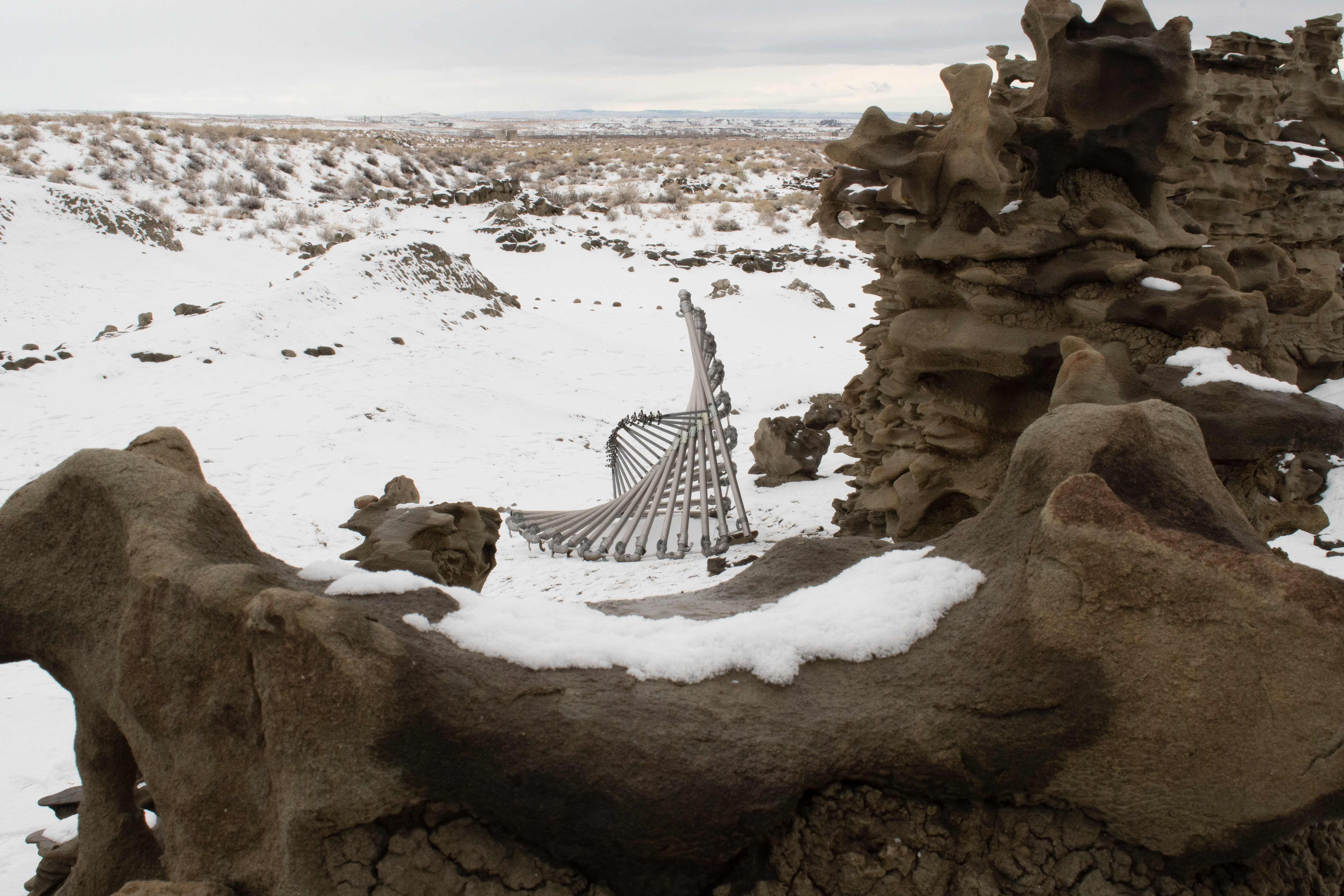

Photography by Hudson Kendall